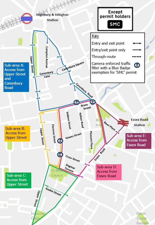
At Islington Council, we’re determined to create greener, healthier streets that everyone can enjoy using. To help achieve this, in February 2022 we introduced a low-traffic neighbourhood (LTN) in the St Mary’s Church area as an 18-month trial.
The trial aimed to:
- make it easier and safer to walk and cycle
- clean up the air we breathe
- reduce road danger.
To achieve these aims, we installed traffic filters in:
- Halton Road, just north of the junction with Braes Street and Richmond Grove
- Braes Street where it meets Canonbury Road
- Hawes Street just west of the junction with Shillingford Street
- Cross Street just west of the junction with Shillingford Street.
You can see locations of the traffic filters on Google maps or view the map of the St Mary's Church area low traffic neighbourhood (LTN). A downloadable version of the map is available in the 'useful documents' section of this page.
We have also made pavement improvements where the south-west section of Canonbury Square meets Canonbury Lane. This has made it easier and safer for local people to access the green space in the middle of Canonbury Square.
Anyone interested in volunteering for a greening scheme in the St Mary's Church LTN should email StMarysChurchPFS@islington.gov.uk.
Next steps
Since introducing the LTN in St Mary’s Church, we’ve been listening carefully to your feedback. As our monitoring report from March 2023 shows, the LTN has had a positive impact and largely met its objectives.
The future of St Mary's Church
We will continue to work to improve the local environment in St Mary’s Church, including:
- improvements to pavements so they are accessible for walking, wheeling and using buggies and wheelchairs
- working with local people to add more greening
- monitoring local roads and main boundary roads to help improve conditions for people walking and cycling.
Monitoring
Our pre-consultation monitoring report for the St Mary’s Church trial area was published in March 2023. This report includes data collected approximately one year on from the launch of the people-friendly streets trial.
View the full monitoring report and appendix in the useful documents section at the bottom of this webpage.
Consultation
- We held a public consultation on the St Mary’s Church people-friendly streets neighbourhood between 29 March and 26 April 2023.
- We published our pre-consultation engagement results report in July 2023. This report includes all feedback up until the public consultation (29 March to 26 April 2023) from Commonplace and trial feedback surveys, email correspondence, formal objections and stakeholder meetings.
- We published our independently written consultation report in July 2023. This report includes feedback received through the public consultation.
You can find a summary of findings on our St Mary's Church consultation web page.
Reports
You can find a list of documents published in the 'useful documents' section including:
- St Mary's Church permanent Delegated Decision Report
- St Mary's Church permanent Equalities Impact Assessment (Appendix 3)
- St Mary's Church permanent response to objections (Appendix 6)
- St Mary's Church permanent assessment of benefits and disadvantages (Appendix 8)
- St Mary's Church low traffic neighbourhood pre-consultation monitoring report
- St Mary's Church low traffic neighbourhood pre-consultation monitoring report appendix
- St Mary's Church low traffic neighbourhood pre-consultation engagement report
Map of the St Mary's Church low traffic neighbourhood


